review by MGVH - 2008.11.15
The main focus of this review will be on the mapping resources within the new QuickVerse 2009 for Windows, namely, Hammond's Atlas of the Bible and especially the Parsons Bible Atlas (2nd ed.).
Many years ago I started using QuickVerse in one of its earliest editions when it was among the first Bible software programs available. (Remember those 5.5" floppies?) I eventually moved on to programs more adept at dealing with original language texts, but one of the nice features of the old QuickVerse was the Bible Atlas program. QuickVerse has gone through quite a few transitions since then, but this latest 2009 edition provides an update to that Bible Atlas program.
Before I get to the reviews of the atlases, I will offer a few observations on the program itself. The program installed easily enough from a single CD. One should register the program upon first run rather than from the setup menu. (I ended up having to register twice to get rid of the reminder screen.) Since I was planning to focus on the Parsons Bible Atlas, it was perplexing to me that I could not find this resource anywhere. Perhaps there was some omission in these newly released editions, but it turns out that the Atlas resource somehow was omitted from the CD. An email to QV support and a phone call later, within a day, and I was provided with the directory of files to download.
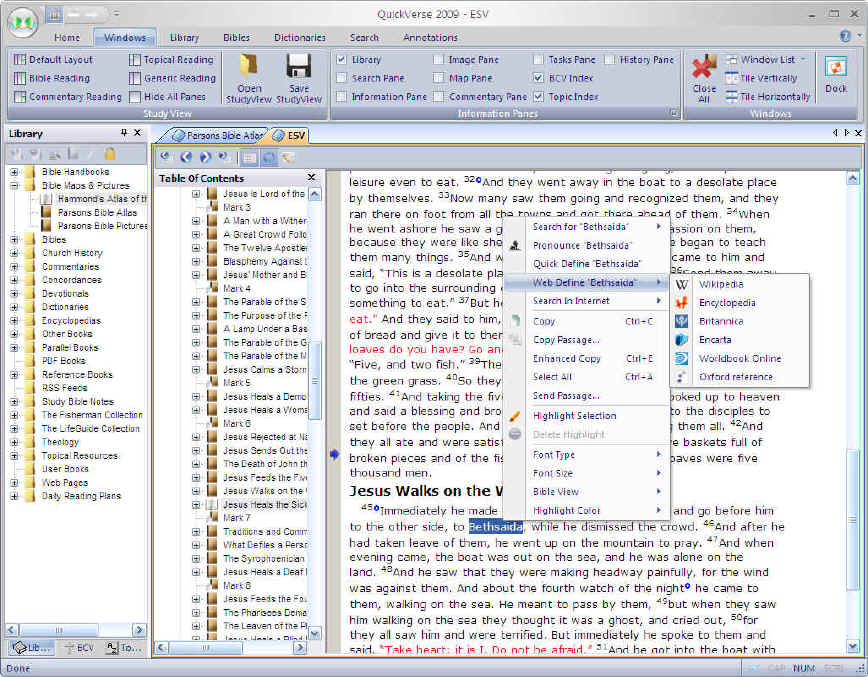
Upon starting the program, the first thing I noted was that it has an attractive, functional, and intuitive interface that uses a mixture of panes and tabs. There are a number ways to personalize the interface and set preferences, and it even provides some helpful suggested layouts that depend upon the kind of work you are planning to do. There is a good variety of English Bible translations provided in the Standard edition and quite a few other useful resources, though a number of them are the old chestnuts widely available on the web. (Check the product comparison chart to see what is available in the various editions.) All in all, I believe that this program would be quickly and easily learned by someone who wanted simply to jump quickly into studying the biblical text.
As I started to focus on its mapping capabilities, I started by looking for a direct link from a location mentioned in a biblical text to maps, but this feature is not available. On the other hand, there are links from any word/phrase in a biblical text to Wikipedia, HighBeam Encyclopedia, Encyclopedia Britannica, Encarta, Worldbook, Oxford Reference and also to Google, Yahoo, and MSN Live Search with the browser window opening within the program.
The fastest way to get to the maps is to open the resource directly from the Bible Maps & Pictures directory of one's library. There are three resources: Hammond's Atlas of the Bible, Parsons Bible Atlas, and Parsons Bible Pictures.
I'm guessing that there must be at least 1000 pictures. They are all 360 x 240, 96dpi pics (which is not particularly good resolution) sorted by biblical verse or by title. They are well organized with helpful captions and links to biblical texts, but the pictures are somewhat dated. (I'm guessing 10+ years old?)
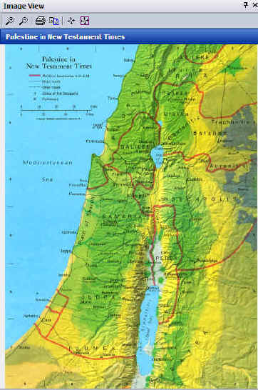
This set includes 54 maps reflecting a good variety and selection of maps likely to be used as one is studying the Bible. They are, in fact, scans of printed maps from the 1984 edition of the Hammond Atlas of the Bible Lands. As such, the maps are of various dimensions, but they reflect their book heritage, since they are more appropriate for portrait viewing than landscape viewing on a computer screen. Clicking on a topic, one is provided with a helpful description, and included with the description is a link to the relate map. The descriptions have links to biblical texts, but the maps are not interactive, and one cannot use a scroll wheel to move or zoom map views. The maps are generally of good quality and attractive. There are 3 types of maps: full color, blue/gray relief, and diagrams of 12 cities.
This set includes 106 articles and their related maps. There appear to be about 1000 map. They are generally in landscape orientation which is better for onscreen viewing. The maps are BMP files with 71dpi, most suitable for 640x480 viewing. There is some variety in unzoomed map size, but they can be viewed at larger sizes without visual problems. They will be acceptable for projection or for printing for handouts if not overly enlarged.
If the maps look familiar, it is because they are maps from the 1998 edition of Parsons Bible Atlas.
The articles are either excerpts from the Baker Encyclopedia of the Bible (1988)
or The Revell Bible Dictionary (1990).
To access the maps:
As noted above, one cannot go from a biblical text, highlight a geographical reference, and go directly to an appropriate map.
One can, however, highlight a location in a biblical text, and then use the menu to Search > Search Books > choose the Atlas and find the articles with associated maps where the site is mentioned.
Clicking on the map should open a �Map Pane,� but there seems to be a bug in the program where it unsuccessfully tries to open the map in an �Image Pane.�
So, the only sure way to open a map is the following:
Opening the Atlas module, one can choose to start with a Table of Maps, an alphabetical list of the events charted on maps with the atlas, or an alphabetical list of location articles.
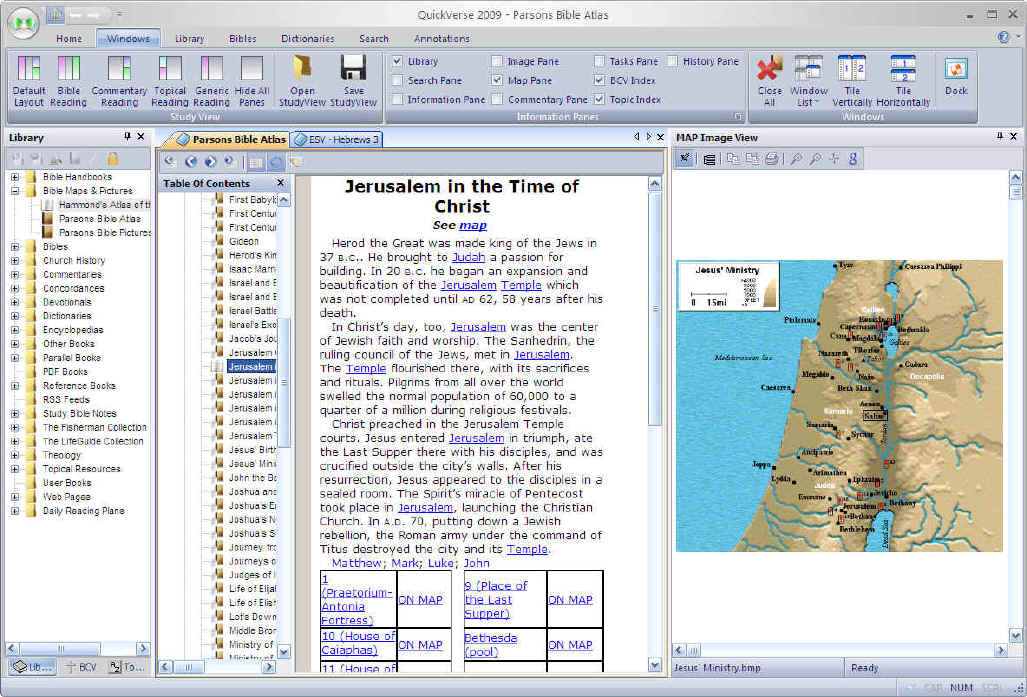
Maps can be viewed within the program or undocked, moved anywhere on the screen, and resized. This is especially nice if one has a dual monitor display.
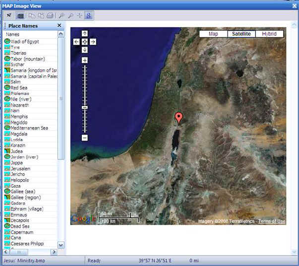
A list of place names can be toggled on/off, and clicking on a name will highlight it on the map.
Maps can be zoomed using the mouse scroll wheel. Clicking and dragging on a map will provide a distance measurement. Latitude/longitude coordinates are provided as well.
The icons for copying the map or the view, sending the map to the printer, or zooming do not seem to work (they do for the similarly laid out Image Pane), but right-clicking on the map provides those options. If
I recall correctly, one could hide the red, exclamation point event markers in
the original program, but this does not seem possible in this edition

Do note, however, the blue, g=Google icon. (Just above "Jesus" on the map above.) When online, clicking on this icon will change the view to that of Google maps. Clicking on a location in the table of place names will locate those on the Google map which is zoomable and moveable and for which one can choose the map, satellite, or hybrid view.
Clicking
on a location name will summon a short article describing significant events
that happened at the specified location with links to appropriate maps. (Another
minor bug: For
some maps and some locations, clicking on the site will bring you to the article
after the one you want. E.g., in the Apostle Paul Base Map, clicking on Troas
[which is incorrectly confused with and located at Troy ~15 miles to the
northeast] brings up the article on Tubal which follows the article on Troas.
I've always
liked the simplicity of the Parsons Bible Atlas maps which allows one to focus
quickly on basic geography matters. Other programs may have more attractive
maps, but the Parsons ones are quite functional.
I do also like that locations and events are connected with an article, and the article is connected with a map. I think that is how most people would work with map data. If I start with an article, it's nice to have some background info on the location/event, and then I want to see where it is on a map. If I start with a map, I want to be able to click on a location and go to the article to find out more about the place.
On the negative side, I noted that there are a number of bugs in this initial release. While I like the maps functionality, they also have their limitations: they do like a little 'old,' and their resolution for display is limited. I also think there should be a right-click link from a location mentioned in a biblical text to an option offering to see where this place in mentioned in the atlas. I would also like the capability of editing the map data (removing the event markers, adding new places, moving points that are slightly off, etc.), but this would add a level of complexity that this program generally tries to avoid.
All in all, for an entry level Bible package geared for laypersons who desire a simple and intuitive interface, QuickVerse2009 represents a good value.